Learn the basic concepts of SAP BusinessObjects Web Intelligence 4.2. With these easy step-by-step instructions, learn how to configure geographic data within a Web Intelligence 4.2 query so that geographical data can be displayed and analyzed within both a map and chart. Also learn how to configure state and city data fields for analysis.
Key Concept
SAP BusinessObjects Web Intelligence is an ad-hoc query and reporting environment that provides an easy-to-use interface with query features that enable business analysts and nontechnical information consumers to ask spontaneous and iterative business questions of their data. Web Intelligence contains a highly interactive data interface that allows the report consumer a great deal of flexibility to view data from different perspectives. With Web Intelligence, report consumers can intuitively build and edit queries and reports to reflect their latest information needs. New functionality has been included within the release of Web Intelligence 4.2 that enables better analysis on geographical data. Web Intelligence 4.2 also includes the capability of generating maps and charts.
With the release of SAP BusinessObjects 4.2, new functionality has been included within the Web Intelligence reporting tool that allows users to view and analyze geographic data (country, region, state, county, and city). Subsequently Web Intelligence 4.2 now enables visual analysis of geographic data within both maps and charts similar to the geographic analysis that could be performed within SAP Explorer and SAP Lumira. This new geographic analysis of data within Web Intelligence 4.2 enables users to achieve more advanced data analysis and to be able to make more informed decisions about geographic data.
I explain some basic concepts within the Web Intelligence 4.2 query and reporting tool. I provide step-by-step instructions on how to configure geographic data within a Web Intelligence 4.2 document so that the geographical data can be displayed and analyzed in both a geographic map and chart format. In addition, I show how to configure geographic data fields using Web Intelligence 4.2 so that the geographic data can be analyzed within both geographic maps and charts.
Step 1. Connect to the SAP BusinessObjects 4.2 BI Launch Pad
To configure and use the geographic map and chart functionality within Web Intelligence 4.2, a user must have the following:
- Access to the SAP BusinessObjects 4.2 BI launch pad application
- Access to the SAP BusinessObjects 4.2 Web Intelligence application
- Create/edit rights within Web Intelligence
An administrator of SAP BusinessObjects should be able to set these rights for any users of the system as needed. Once you’ve established that you have the prerequisites in place, connect to the BI launch pad application using an Internet browser with the URL for the BI launch pad application (screen not shown), and log in to the SAP BusinessObjects 4.2 BI launch pad application.
Step 2. Create a New Web Intelligence Document
After you log in to the BI launch pad application, open the Web Intelligence application by clicking Applications and then Web Intelligence as shown in
Figure 1.

Figure 1
Open the Web Intelligence application in the BI launch pad
Within the Web Intelligence application page, click the new icon or select Ctrl+N as shown in
Figure 2 to create a new Web Intelligence document.
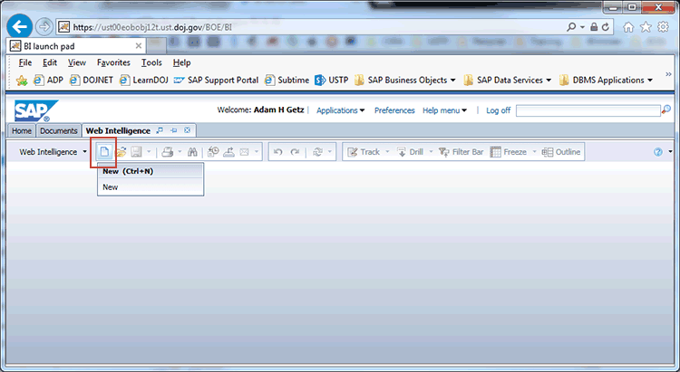
Figure 2
Create a new Web Intelligence document
Within the Create a document dialog screen, select the data source for the Web Intelligence document as shown in
Figure 3 and click the OK button. In this example, I chose Excel as the data source for the document. However, any of the other types of data sources can be used as well with geographic data.
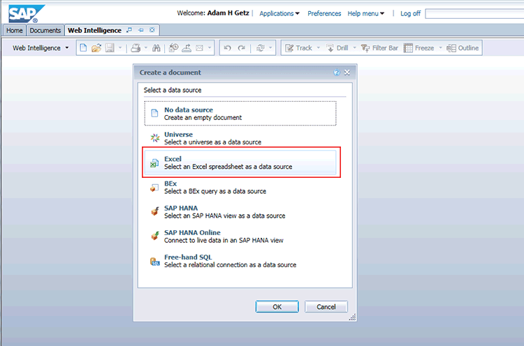
Figure 3
Select a data source
Now pick an Excel document from a folder within the BusinessObjects server as shown in
Figure 4 and click the Open button. In this case, I chose the Excel file Outlet_Facts from my Favorites folder.
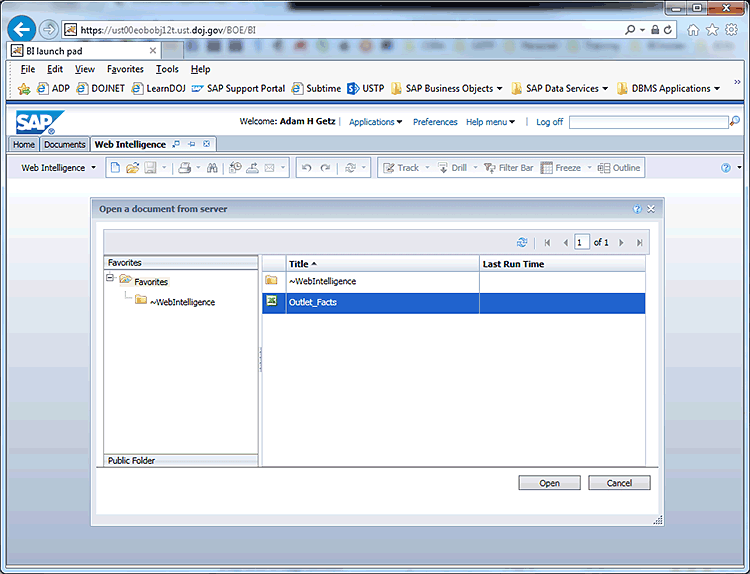
Figure 4
Select a document from the BusinessObjects server
Then select the fields to be included within the document from the Query Panel as shown in Figure 5. When you complete your selections, click the Run Query button. In this example, I included the geographic fields City and State within the Result Objects.
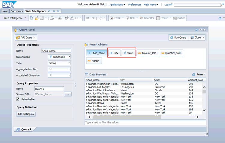
Figure 5
Query Panel with Result Objects
Note
Be sure to include at least one geographic field (Country, State, or City) and at least one numeric field to be able to take advantage of geographic maps and charts. Other dimension fields that are non-geographic can be also be included in the Result Objects without affecting the geographic mapping functionality.
After you execute Run Query from the Query Panel, a new Web Intelligence document appears as shown Figure 6.
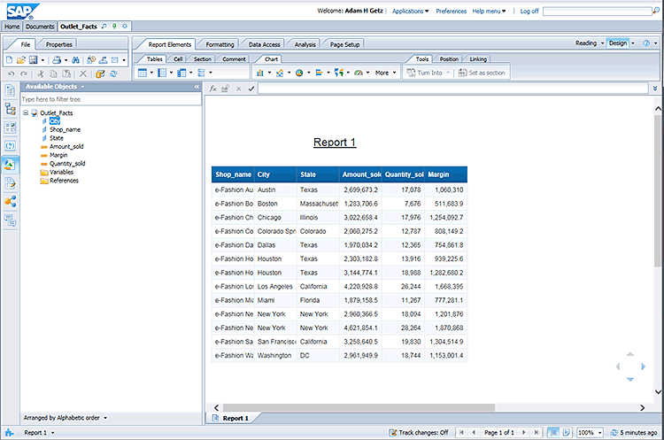
Figure 6
New Web Intelligence document
The document will open in Design mode as shown in Figure 7. The Design button in the top right is selected, and Available Objects are shown in the left side panel. The button converts the mode of the report from Preview to Design.
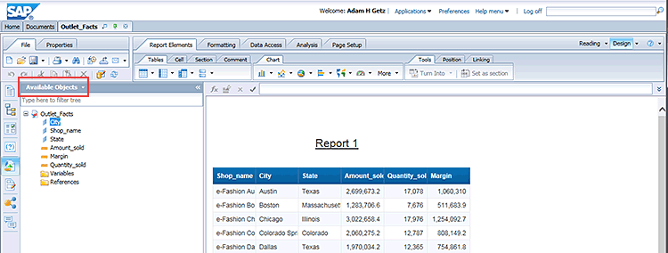
Figure 7
Report in Design mode
Step 3. Map Geographical Data Within Web Intelligence Document
Within Design Mode of the Web Intelligence document and within the Available Objects side panel, right-click the City dimension field and select Edit as a Geography and then By Name on the context menu as shown in Figure 8.
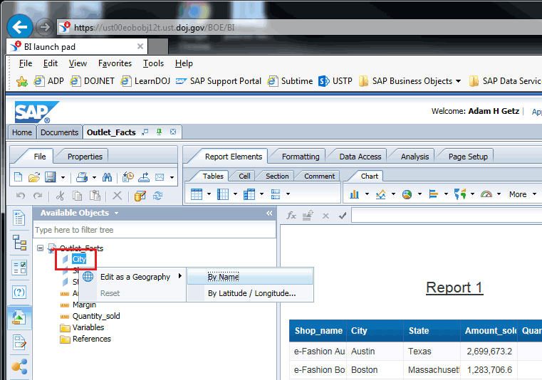
Figure 8
Selections within the Design mode
Select City from the Level drop-down menu as shown Figure 9.
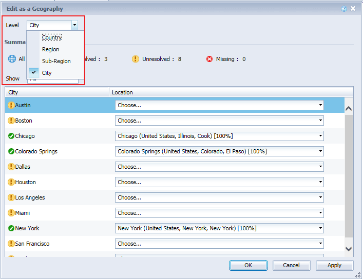
Figure 9
Edit as a city
Note
The City/Location table displays all the values returned by the city dimension and proposes a matching location. Some cities can be automatically matched to a location if a city with that name only exists in one country and state. However, some city names exist in multiple states or countries and cannot be automatically matched. Cities without a recognized location show as unresolved.
For each of the unresolved city/location pairings, choose a location from the location drop-down menu to match with the corresponding city, as shown in Figure 10. Click the OK button. In this example, I chose the city of Los Angeles and matched it with the location of Los Angeles (United States, California, Los Angeles) [100%]. There are five available choices for the location of Los Angeles.
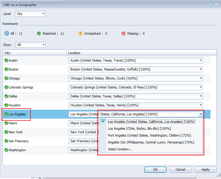
Figure 10
Match unresolved city/location pairings
Now right-click the State dimension field and select Edit as a Geography and then By Name on the context menu as shown in Figure 11.
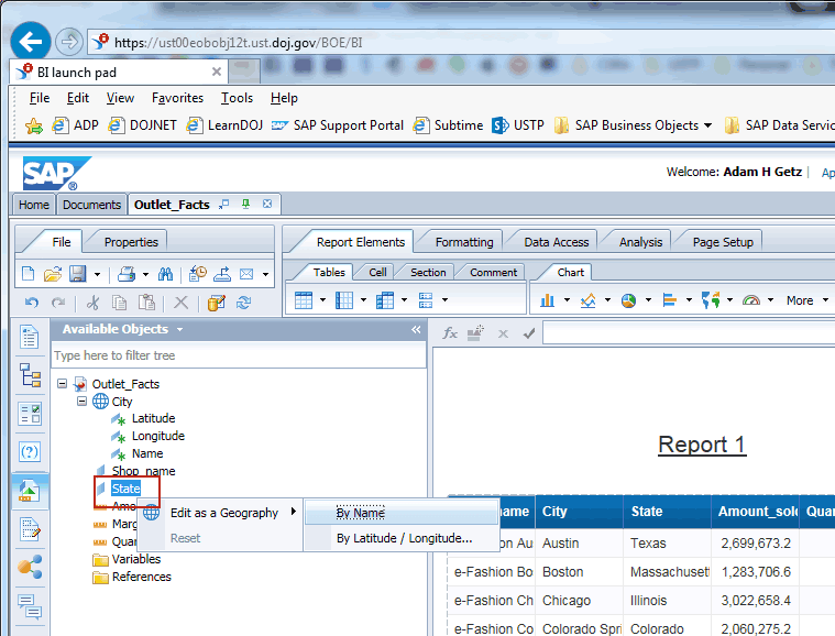
Figure 11
Selections on the context menu
Select Region from the Level drop-down menu as shown Figure 12.
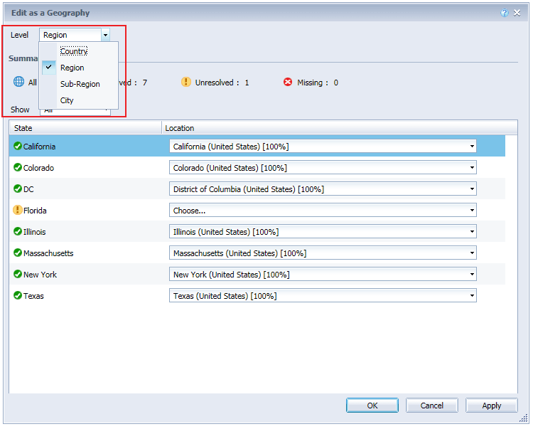
Figure 12
Edit as a region
Note
The region level matches a US state with a location, and the sub-region level matches a US county with a location.
For each of the unresolved state/location pairings, choose a location from the location drop-down menu to match with the corresponding state as shown in Figure 13 and click the OK button. In this example, I chose the state of Florida and matched it with the location of Florida (United States) [100%]. There are two available choices for the state of Florida.
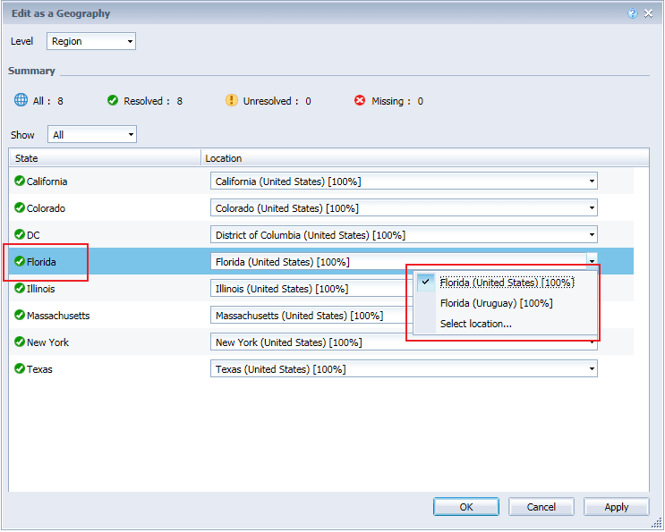
Figure 13
Match unresolved state/location pairings
When you have finalized the mapping for the chosen field, close the Edit as a Geography dialog box. In the Available Objects side panel, the dimension now appears as a geographical dimension with details of Latitude, Longitude, and Name as shown in Figure 14. In this example, City and State now appear as geographic dimensions.
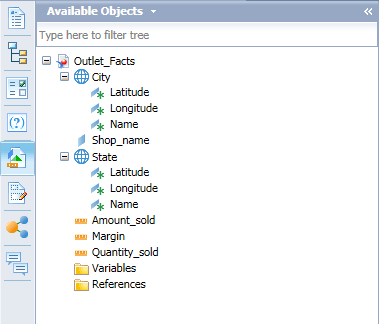
Figure 14
The Available Objects panel with geographic dimensions
Step 4. Create a Geographic Chart
To create a geographic chart within a Web Intelligence document, an existing query with a geographic dimension and a numeric field must exist within the document. In my example, the query was added to the document at the time of the document creation as shown in Figure 6. The query includes geographic fields of City and State as well as numeric fields of Amount_sold, Quantity_sold, and Margin.
Now convert an existing query within a document into a geographic chart. Right-click the report element containing the returned data set and select the Turn Into and then More Transformations commands in the context menu as shown in Figure 15.
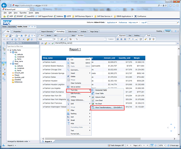
Figure 15
Convert an existing query
Within the Turn Into dialog box, select the Geographic section from the left panel, select the chart type from the middle panel, and enter chart parameters (Map Item Key, Geo Pie Sector Color, and Map Item Value) from the right panel as shown in Figure 16. When you are finished, click the OK button. In this example, I chose the following settings:
- Chart Type: Geo Pie Chart
- Map Item Key: City (Query 1)
- Geo Pie Sector Color: State (Query 1) and City (Query 1)
- Map Item Value: Amount_sold
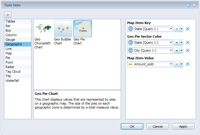
Figure 16
Select the settings
Note
Three types of geographic charts exist within Web Intelligence 4.2:
- Geo Choropleth Chart – This chart type displays values that are represented by colors on a geographic map. The colors of the geographic zones are determined by a numeric value.
- Geo Bubble Chart – This chart type displays values that are represented by bubbles on a geographic map. The size of the bubbles on each geographic zone is determined by a numeric value.
- Geo Pie Chart – This chart type displays values that are represented by pies on a geographic map. The size of the pies on each geographic zone is determined by a total numeric value.
The document query is then converted into a geographic chart as shown in Figure 17. In this example, a Geo Pie Chart is displayed.

Figure 17
Web Intelligence document with Geo Pie Chart with state and city data
To view the numeric value related to a geographic area, mouse over the respective pie corresponding to the area as shown in
Figure 18. In this case, I place the mouse over the blue part of the pie corresponding with the state of California and city of Los Angeles. Within the bubble help, the name of the state of California, city of Los Angeles, the total value of Amount sold for Los Angeles appears with the fraction of total value for the state appearing in parenthesis.
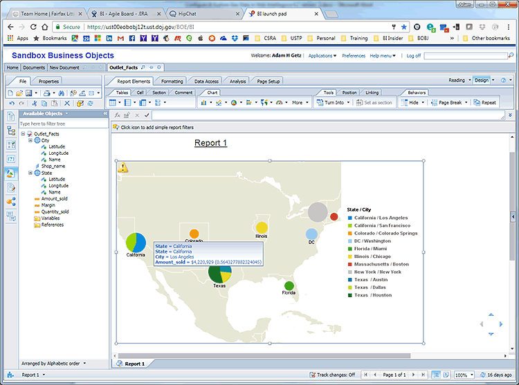
Figure 18
Mouse over the geographic pie
Now convert the existing geographic chart into a Geo Choropleth Chart. Right-click the geographic chart and select the Turn Into and then the More Transformations commands in the context menu as shown in Figure 19.
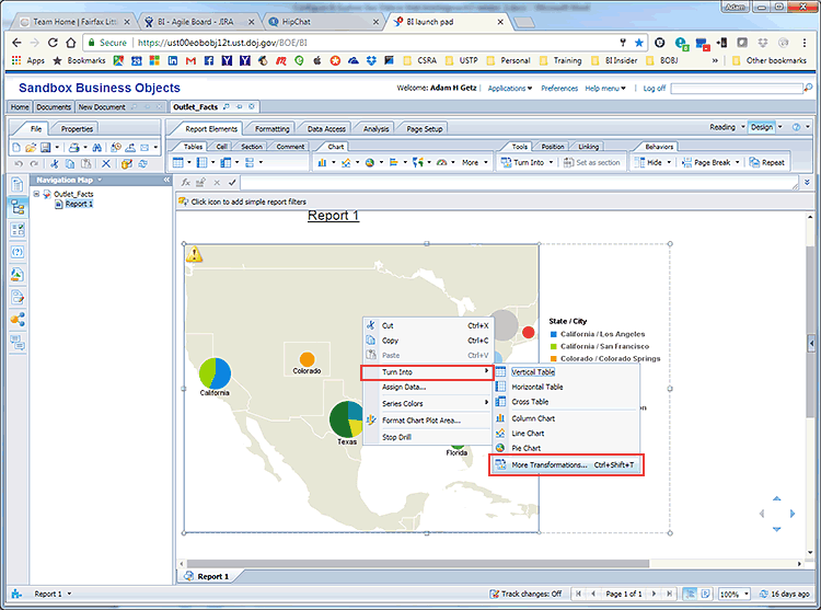
Figure 19
Convert to a Geo Choropleth Chart
Now a Geo Choropleth Chart appears as shown in Figure 20. In this example, I chose the following:
- Chart Type: Geo Choropleth Chart
- Map Item Key: State
- Map Item Value: Amount_sold
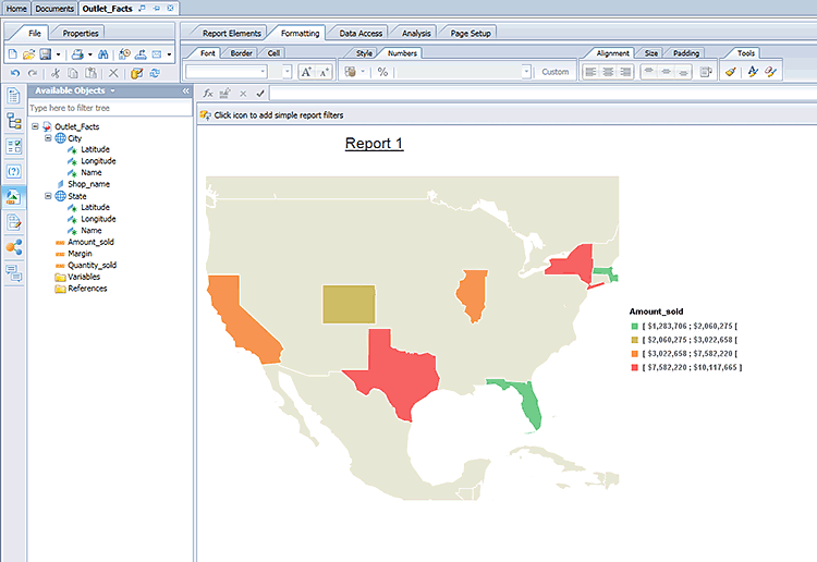
Figure 20
Geo Choropleth Chart with state data
To view the numeric value related to a geographic area, mouse over the respective geographic zone as shown in
Figure 21. In this case, I place the mouse over the state of California. Within the bubble help, the name of the state of California and the total value of Amount_sold for California appear.
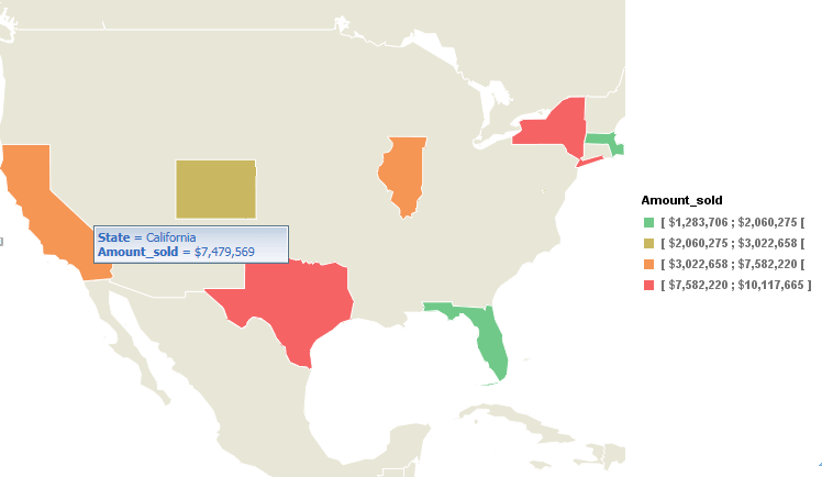
Figure 21
View the geographic zone
Now convert the existing chart into a Geo Bubble Chart. Right-click the geographic chart and select the Turn Into and then the More Transformations commands in the context menu as shown in Figure 22.
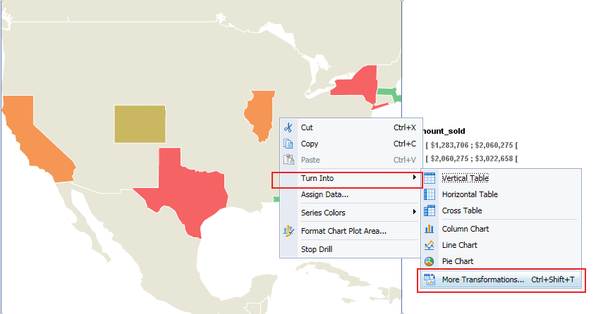
Figure 22
Convert to a Geo Bubble Chart
Now a Geo Bubble Chart appears as shown in Figure 23. In this example, I chose the following:
- Chart Type: Geo Bubble Chart
- Map Item Key: State
- Map Item Value: Amount_sold
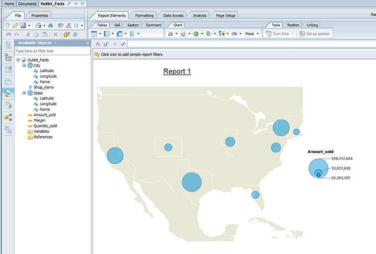
Figure 23
Geo Bubble Chart with state data
To view the numeric value related to a geographic area, mouse over the respective geographic zone as shown in
Figure 24. In this case, I place the mouse over the state of Texas. Within the bubble help, the name of the state of Texas and the total value of Amount_sold for Texas appear.
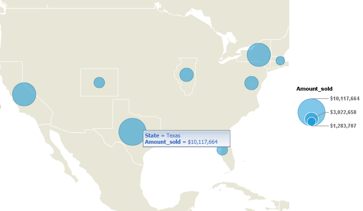
Figure 24
View state data in the Geo Bubble Chart
Adam Getz
Adam Getz currently serves as a Manager, Business Intelligence for CGI Federal. In this position, he is leading a large business intelligence and data warehousing implementation for a federal client. He is a thought leader in the field of information technology and an expert in the deployment of leading business intelligence, database management, and data integration products. He has presented at a variety of local, national, and international events, including the 2006 BusinessObjects International Conference, 2007 Oracle BIWA Summit, 2008 Oracle Open World, and 2010 and 2011 ASUG SAP BusinessObjects User Conferences. In addition, Adam is the creator and main author of
bi-insider.com, a website, portfolio, and blog that provides rich technical and functional content to business intelligence and data warehousing professionals. He has also published numerous technology white papers that have focused on various topics within business intelligence and data warehousing. Adam currently serves as the chairperson of the Washington DC Business Objects User Group.
You may contact the author at
adagetz@yahoo.com.
If you have comments about this article or publication, or would like to submit an article idea, please contact the
editor.