Learn basic concepts of SAP BusinessObjects Explorer 4.1. With these easy-to-follow, step-by-step instructions, learn how to configure geographic data within an Explorer 4.1 information space so that geographical data can be displayed and analyzed in a map. Also learn how to configure country, region, state, and city data fields for analysis.
Key Concept
An SAP BusinessObjects Explorer 4.1 information space is a pre-defined dataset that connects to a BusinessObjects universe, selects data fields from the source universe, and enables the presentation of data within the Explorer application. An information space is a collection of data fields that map to organizational data for a specific business operation or activity (i.e., sales, employee performance, inventory, orders, and fulfillments). Fundamentally, the information space is an intermediary or middleware component that connects a BusinessObjects universe to a BusinessObjects Explorer application.
Fundamentally, SAP BusinessObjects Explorer 4.1 (a relatively new end-user application within the BusinessObjects 4.1 application suite) allows users to rapidly explore data in a highly graphical and intuitive format. The application also contains functionality to allow users to view and analyze geographic data (country, region, state, county, and city) with a map that is included within the tool. This graphical map tool allows for advanced analysis of data that cannot be provided by text-based analysis tools.
In this article, I provide a demonstration and step-by-step guide for how to configure geographic data within an SAP BusinessObjects Explorer 4.1 information space so that the geographical data can be displayed and analyzed within a map. Additionally, I provide readers with instructions for how make geographic data available for Explorer 4.1 maps and how to use Explorer 4.1 geographic maps for analysis. This article is intended for users who are responsible for configuration of Explorer 4.1 information spaces.
Step 1. Connect to SAP BusinessObjects Explorer 4.1
In order to configure and use the geographic map functionality within Explorer 4.1, a user must have the following prerequisites.
- Access to the SAP BusinessObjects BI launch pad application
- Access to the SAP BusinessObjects 4.1 Explorer application
- Have view rights to information spaces
An administrator of SAP BusinessObjects should be able to set these rights for any users of the system as needed. Once you’ve established that you have the prerequisites in place, connect to the BI launch pad application using an Internet browser with the URL for the BI launch pad application (screen not shown), and log in to the SAP BusinessObjects Explorer 4.1 application.
Step 2. Modify an Existing Information Space
In the screen that opens (the SAP BusinessObjects Explorer home page, shown in
Figure 1), you can view the list of existing information spaces. (The major component that creates the foundation of Explorer is known as an information space.)

Figure 1
The home page of SAP BusinessObjects Explorer
Click the Manage Spaces link at the top of the window and the Manage Spaces page of SAP BusinessObjects Explorer screen opens (
Figure 2). Here you configure existing information spaces, create new information spaces, and index existing information spaces.

Figure 2
The Manage Spaces tab of BusinessObjects Explorer
Navigate to an existing information space that contains fields for geographic data (i.e. country, state, region, or city). To edit or configure the selected information space, either single-click the tittle of the information space or choose Configure from the Action drop-down field (on the right). In this example, I select the existing information space Explorer eFashion-Demo V1.1 to configure.
The next screen that opens (
Figure 3) is the Properties tab of the selected information space (Explorer eFashion-Demo V1.1).

Figure 3
Open the Properties tab of an existing information space
Navigate to the Objects tab of the selected information space (
Figure 4). Here you can configure the Country facet to be a geographic field. Select Country from the list of Facets (under Preferences) in the middle of the screen. (Facet is term unique to Explorer; it is the text or describing value used to identify, group, and filter measurements.) In the Details panel on the right, change the Dimension: type from Standard to Geography. Then select the … (ellipse) icon next to the dimension drop-down. This opens the screen where you can define the parameters of the Country field (
Figure 5).
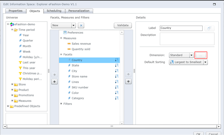
Figure 4
Select the country facet and change the dimensions

Figure 5
Define the geographic parameters window for country
Here you select the Geographic Level (Country) and then click the Load button.
The system then attempts to match all the values in the country facet with the existing known countries (
Figure 6). The Explorer tool includes a pre-defined set of countries, regions, states, and cities, known as propositions. Each of these pre-defined, built-in geographic locations (propositions) correspond with locations on the Explorer geographic maps. In order for the maps to work correctly, the underlying geographic data selected in the information set within the selected facet must be matched with pre-defined geographic locations built into the tool. In this case, the Country facet value USA matches and there are no errors that need to be corrected. Notice that there are 13 Matching values, 0 To Define values, and 0 Unlocalized values.

Figure 6
Define the geographic parameters window for country
Note
In the screen in
Figure 6, the Matching, To Define, and Unlocalized statuses mean the following.
- Matching status means that the geographic value within the selected facet matches with a pre-defined geographic proposition.
- To Define status means that a facet value matches with multiple
proposition values. This status is common with a city that could be
included in multiple countries (e.g., San Jose, CA, USA, and San José,
Costa Rica). The system does not know which proposition should be
selected, so the user has to select the correct proposition for the
facet value (i.e., for a city facet value of San Jose, the user can
either select San Jose, CA, USA rather than San José, Costa Rica for the
matching proposition).
- Unlocalized status means that a facet value does not match with
any existing proposition values. This could be the case if the facet
value is misspelled or is a small or obscure geographic location. In
this case, the user should select a proposition value that is either
close in spelling or close in proximity to the facet value. For example,
the actual city facet value could be spelled as Wash DC and the system
may not recognize this spelling and may not be able to match any
existing proposition values. In this case, the user should select
Washington, DC as the matching value.
Click the OK button and you’re taken back to the screen in
Figure 4. This time, select State from the list of facets in the middle of the screen. Then you make your selections for this new parameter—state—in the same way that you did for the country parameter. Finally, select City from the list of facets in the middle of the screen. Then you make your selections for this new parameter—city—in the same way that you did for the country and state parameters.
Step 3. Explore the Modified Information Space
Once you’ve finished defining all the geographic facets (i.e., country, state, and city) for the selected information space, go back to the Objects tab (
Figure 4). Click the OK button and you’re taken to the screen in
Figure 7. On the left of the screen, you now see the universe eFashion-demo.unv in the webi universes folder.

Figure 7
Index the selected information space
Double-click this universe on the left and the screen in the middle opens. Select the space Explorer eFashion-Demo V1.1 link and then, in the panel on the right, select the Index Now option. Selecting this index action compiles the contents of the selected information space. This process may take a few minutes to complete.
Note
The Index Now option updates the data and metadata included within
information spaces. Before the information space can be made available
to end users and appear on the BusinessObjects Explorer Management Page –
Information Spaces subpage it must be indexed. Information spaces
should be also be indexed after any editing so that any modifications
are included. If an information space is not re-indexed after
reconfiguration, it will not be updated on the Home Tab and changes to
the information space are not visible to users.
Once the information has been successfully indexed, got to the Home tab (
Figure 8) and click the Refresh list button. This updates the list of information spaces and makes the data within the newly indexed information space available to the user. Double-click the Explorer eFashion-Demo V1.1 link to the information space. This opens the screen in
Figure 9 where you can explore the information space.

Figure 8
Refresh the Explorer home page to update the list of information spaces

Figure 9
Explore the new information space
Click the Geography button in the lower left side to change the chart type from a bar to geography. The chart display changes from a bar chart format to a geography format with a focus on the country facet (
Figure 10).

Figure 10
Geography chart with a country focus
Mouse over any part of the United States map (in red). When you hover over the country, the name of the country appears along with the name and value of the selected measure from the top of the Explorer page (
Figure 11). In this case, Quantity Sold is the measure that has been selected and is currently being displayed for the Country USA.
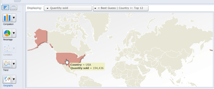
Figure 11
Display the country name and the value of the measure
You can double-click anywhere on the map of the USA to drill down to the state level (
Figure 12). The country USA has been added as a filter, a map of the states appears, and the data table (on the right) contains the values for all the states.

Figure 12
Geography chart with a state focus
Next, mouse over California (in green on the left). When you hover over the state, the name of the state appears, along with the name and values of the selected measures (from the top of the Explorer page). In this case, Quantity Sold is the measure that has been selected and is currently being displayed (
Figure 13).

Figure 13
Mouse over California to display the state name and the values of the measure
Using these same steps, you can drill down further in the map to see city-specific information.
Adam Getz
Adam Getz currently serves as a Manager, Business Intelligence for CGI Federal. In this position, he is leading a large business intelligence and data warehousing implementation for a federal client. He is a thought leader in the field of information technology and an expert in the deployment of leading business intelligence, database management, and data integration products. He has presented at a variety of local, national, and international events, including the 2006 BusinessObjects International Conference, 2007 Oracle BIWA Summit, 2008 Oracle Open World, and 2010 and 2011 ASUG SAP BusinessObjects User Conferences. In addition, Adam is the creator and main author of
bi-insider.com, a website, portfolio, and blog that provides rich technical and functional content to business intelligence and data warehousing professionals. He has also published numerous technology white papers that have focused on various topics within business intelligence and data warehousing. Adam currently serves as the chairperson of the Washington DC Business Objects User Group.
You may contact the author at
adagetz@yahoo.com.
If you have comments about this article or publication, or would like to submit an article idea, please contact the
editor.